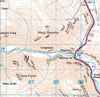
The Craig Navar township is an excellent site to visit and one that I visited today. Access to the site is very easy with parking available on the A822 at Newton Bridge, which in itself is a pleasant place to picnic.Crossing the road and walking for a round half a mile on an easy flat path, that takes you all the way to Loch Tay, you come across the remains of the township.
 |
| Position of Township |
 |
| The Township, as detailed in 1863 |
The township is situated at NN 877 317.
The Ordance Survey Map from 1863 can be
viewed here showing a detailed outline of the township, at this time recorded as in ruins
The site is on the right of the path on a hill and is cosnstructed of the remains of around 11 dwellings, each in varous states of decay, with the majority of walls no higher that 1.5mtrs, although there were some 2 or 3 fine examples of gables standing at a little over 2 mtrs. The remains of each designated 'plot' can still be traced, which gives a good outline of both the village and the size of each site.
Although the majority of the clearances are associated with the Highlands, there were extensive clearing exercises taking place in the lower highland areas, such as Perthshire. The 2nd Marquess of Breadalbane carried out an act of clearing parts of his huge estates and replacing people with sheep. The areas making up Glenquaich, which runs north-west from Amulree towards Loch Tay. From the furthest point the River Quaich runs South East from the hills into Loch Freuchie. Along the shore line of Loch Freuchie there are a further several sites of former townships and communities.
I have added some pictures as a guide to the township.
(copyright:Author)
 |
| East Approach to Township |
 |
| Looking West across township |
|
|
|
|
 |
| Looking West across Township |
 |
| A Gable example |
 |
| Corner stones on south facing gable |
 |
| The remains of a dwelling |
 |
| Lower dwelling remains |
 |
| Middle positioned dwelling |


Smashing
ReplyDelete